What is hyperspectral remote sensing?technical characteristics,applications
Hyperspectral remote sensing is the current frontier of remote sensing technology, the use of many very narrow electromagnetic wave bands from the object of interest to obtain relevant data, contains a wealth of spatial, radiometric and spectral triple information, the development of which is a revolution in remote sensing, but also caused a fundamental change in data processing and information analysis techniques, so that the original in the broad-band remote sensing in the undetectable material, in hyperspectral remote sensing can be detected. So what is hyperspectral? It starts with the visible band of the sun.
Why is the world colorful?
Whether it is the south of the sky or the change of seasons, why do we feel the world is so colorful? The rainbow that clears up after a rainy day can help us solve the answer. Sunlight is actually mixed-color light, through the scattering of water droplets in the air is broken down into colorful monochromatic light, constituting all the colors our eyes can perceive, this part of the light is defined as the sun's visible wavelengths.
In addition to this the sun's light also contains light in the ultraviolet and infrared wavelengths. However, the same color of light to our human eyes is also a complex color of light containing thousands of bands, which is far beyond the limit of human eyes to distinguish. At the same time, different objects are composed of different elements and their compounds, the structure of the material is also different, which leads to the wavelength of the reflected or scattered light on the surface of the object also shows specificity; different objects in different states of different wavelengths of light reflection or scattering ability is different, but also makes the object has a different color or spectral characteristics, just like the “fingerprints Like the “fingerprint” information, it can distinguish features and atmospheric composition in a fine way. Such unique spectral characteristics of substances form the basis for identifying and analyzing the characteristics of different objects in remote sensing science.
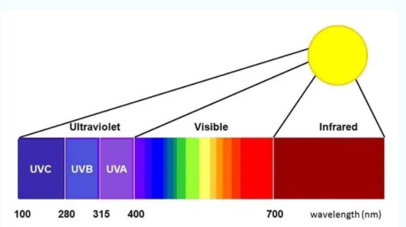
In order to accurately acquire light information in different wavelength bands, the optical remote sensors of satellites have successively adopted multispectral imaging technology and hyperspectral imaging technology, in which light reflected or scattered from objects is divided into specific wavelength bands of light by means of filters, prisms, gratings and other light-splitting devices, and targets are identified and remote sensing is quantified on the basis of the spectral feature information received from the ground or from atmospheric reflection or scattering.
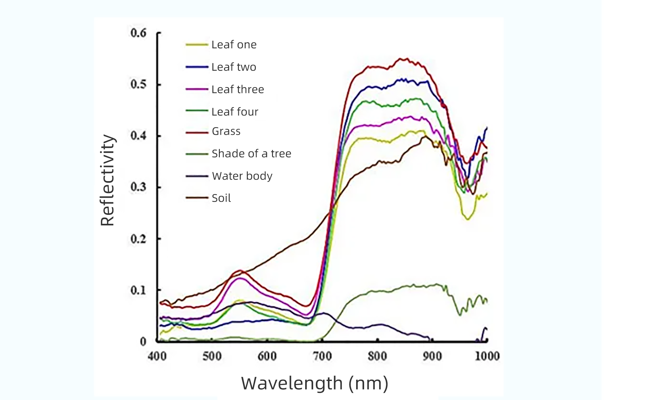
Initially, remote sensing of the ground used a multi-spectral imaging technology system, often only a few channels, each channel contains optical information with wavelengths tens of nanometers wide, and can realize the spectral detection capability in both infrared and ultraviolet directions. However, for similar objects or objects in different states, the characteristic peaks of their reflectance spectra are usually similar, as shown in the figure below, the characteristic peaks of the four species of trees are only slightly different at 960 nanometers, and in order to distinguish between the categories of different tree species, a spectral resolution of less than ten nanometers is required; for example, for the classification and identification of rocks, the occurrence of pests and diseases in crops, the soil has been renovated for farming, and the outbreaks of flora or cyanobacteria, For example, for the classification and identification of rocks, crop pests and diseases, soil renovation and cultivation, water bloom or cyanobacteria outbreaks, air pollution and other problems, which are reflected in the spectra only in a few nanometers of change, the traditional means of multispectral detection is overstretched, and the identification success rate is not high.
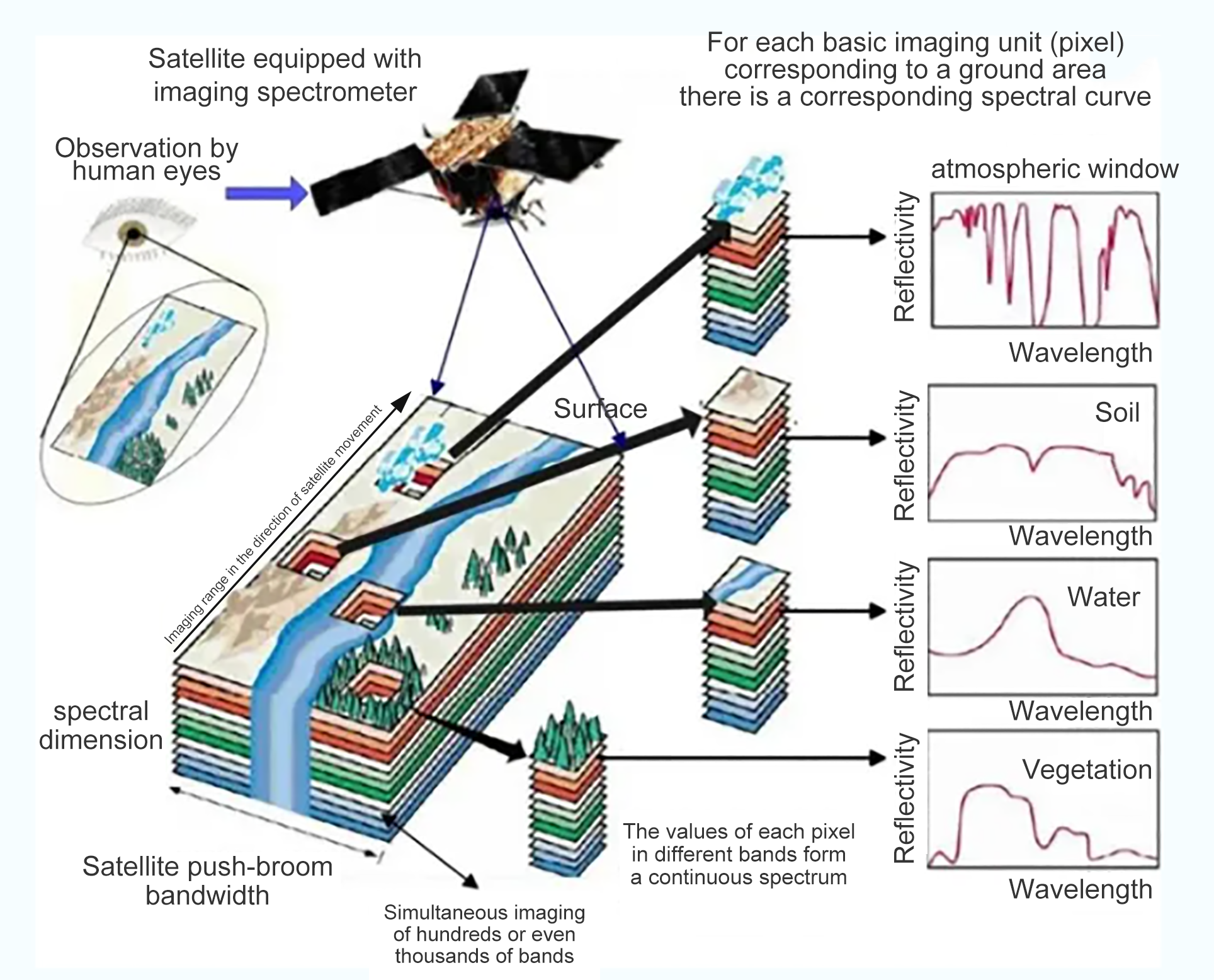
 With the beginning of the development of hyperspectral remote sensing technology in the 1970s, the field of optical remote sensing underwent revolutionary changes and gradually formed a popular frontier technology field. Hyperspectral remote sensing technology is a technology based on very many narrow-band image data, which combines imaging technology with spectral technology to detect the two-dimensional geometric space and one-dimensional spectral information of the target, and to obtain continuous, narrow-band image data with high spectral resolution. Hyperspectral imaging technology is developing rapidly, and the common ones include grating spectroscopy, acousto-optic tunable filter spectroscopy, prism spectroscopy, and chip coating.
What are the technical characteristics of hyperspectral remote sensing?
Hyperspectral (Hyperspectral camera)single-channel band is narrow, its spectral resolution is as high as nanometer (nm) order of magnitude (generally less than 10 nm), the number of spectral channels up to dozens or even hundreds of more, to obtain continuous material reflection / scattering of continuous spectral data, which can be realized in the range of visible, near-infrared, mid-infrared and thermal infrared wavelength band and hyperspectral data acquisition.
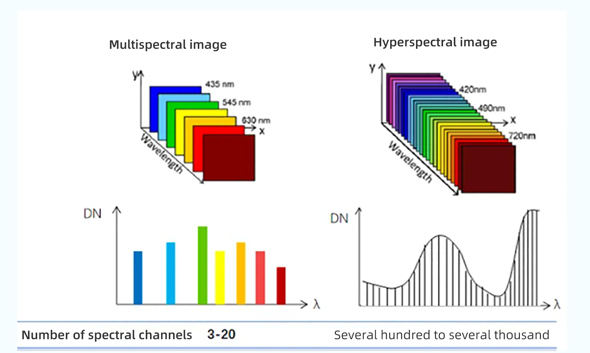
Distinguished from the traditional multispectral remote sensing technology to distinguish targets based on color differences, hyperspectral remote sensing technology can achieve discrete sampling in spectral space, and the targets that can be distinguished are generally those that have obvious differences in spectral space, such as water bodies, vegetation, and bare ground. Hyperspectral remote sensing is a multidimensional information acquisition technology that combines imaging technology and spectral technology, which can simultaneously acquire the two-dimensional spatial information of the target and the third-dimensional spectral information, and analyze the compositional information of the material through the morphology of the spectral curves to identify the target as well as the target features, which can distinguish different categories of the same kind of features. According to different application scenarios, the selectivity of the spectrum becomes flexible and diversified, which improves the ability of distinguishing and identifying features, effectively distinguishes different categories belonging to the same kind of features, realizes “different spectra for the same kind of feature” and “different features for the same kind of spectrum”, and reduces the phenomenon of spectral spatial confusion of the features, such as the phenomenon of different tree species. It can reduce the phenomenon of spectral spatial confusion of features, such as the identification of different tree species and different minerals; at the same time, hyperspectral data can be used for the extraction of bio-physical and chemical parameters, and the biochemical analysis of chlorophyll a, lignin and cellulose of vegetation.
The development of hyperspectral remote sensing technology makes remote sensing from qualitative analysis to quantitative or semi-quantitative transformation, the main application of traditional imaging remote sensing technology is based on qualitative analysis, part of the quantitative analysis results of the accuracy of the results is not ideal, which is obviously related to the imaging sensor's spectral and spatial resolution, the interference of the atmospheric and soil background and other limitations, the hyperspectral resolution imaging remote sensing first breaks through the spectral resolution of the one limit High spectral resolution imaging remote sensing firstly breaks through the limitation of spectral resolution, which largely suppresses the influence of other disturbing factors in the spectral space, which is very helpful for the improvement of the accuracy of quantitative analysis results.
What are hyperspectral applications?
Compared with high-resolution and multi-spectral images, hyperspectral images have high spectral resolution and many bands, which can obtain almost continuous spectral feature curves of features, and specific bands can be selected or extracted according to the need to highlight the target features; the quantized continuous spectral curve data provide conditions for the introduction of image classification into the spectral mechanism model of the features, which contains rich radiometric, spatial and spectral information, and is the synthesis of a variety of information. It contains rich radiometric, spatial and spectral information, and is a comprehensive carrier of various information. Hyperspectral images are widely used in the fields of geomorphological mapping, resource exploration, agricultural remote sensing, environmental remote sensing, forestry monitoring, soil remote sensing, water color remote sensing and atmospheric science.
1. Remote Sensing for Feature Classification
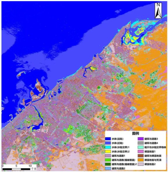
The figure shows the hyperspectral data of Dubai coastal area acquired by hyperspectral remote sensors, which can accurately recognize the information of major categories of features, such as water bodies, buildings, roads, bare soil, etc., through feature classification, and can be subdivided into 3~5 effective subcategories in each major category, and can also recognize the information of vessels in the distant sea.
2. Ore exploration
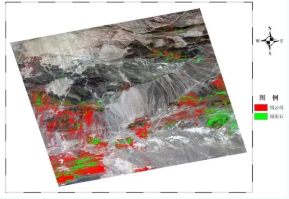
Hyperspectral remote sensing technology can provide a boost to geological exploration. Based on the analysis of the spectral curves of the rocks obtained, the types of mineral distribution and the area of the place can be known. The figure shows that the hyperspectral remote sensing data effectively extracted two kinds of mineral information of sericite and chlorite in Dulan area of Qinghai, and after MNF transformation, it enhances the recognition of lithology and tectonic geology information.
3. Remote sensing of water environment
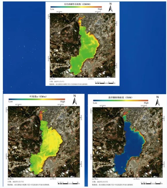
Due to the certain similarity between the spectra of water plants and water blooms and the spectra of vegetation, it is difficult for the commonly used multispectral remote sensing data to accurately identify water blooms and water plants, and only the hyperspectral remote sensing data can capture the detailed spectral differences between the complex and variable water blooms, water plants, and the water body, so as to accurately identify the water blooms and water plants. The figure shows the environmental map of Yunnan Dianchi regional water body acquired by the satellite-borne hyperspectral remote sensor, which can clearly identify the colored dissolved organic matter (CDOM), chlorophyll a (Chl-a), and suspended solids concentration (TSM) in the water body. Meanwhile, the water quality parameters of small rivers and lakes other than Dianchi are also clearly recognizable in the image.
4. Atmospheric remote sensing
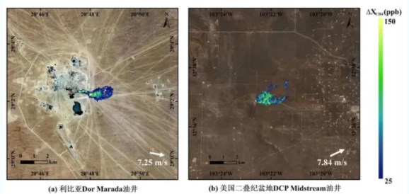
Remote sensing monitoring of methane point source emissions was carried out in Libya and the United States using hyperspectral remote sensing data with optimized methane column concentration inversion algorithms. Figure (a) shows the results of monitoring methane leakage from the Dor Marada oil well in Libya, and figure (b) shows the results of monitoring methane leakage from the DCP Midstream oil well in the Permian Basin of the United States, which can accurately monitor a clear methane emission plume in the region.
Video of UAV hyperspectral camera at work


How can we Help you?
Email*
Phone*
Name*
Country/Region*
Which Products are you interested in?*